Our planet is at a crossroads. From rising global temperatures to unprecedented biodiversity loss, the environmental challenges we face are complex and urgent. For years, we’ve struggled to monitor these changes at scale and today, a powerful combination of technologies are giving us the clarity to act and it’s : Geospatial Artificial Intelligence.
Geospatial AI is the fusion of location based data (from satellites, drones, and sensors) with advanced machine learning. It allows us to sift through massive amounts of information to find specific, actionable insights transforming how we can protect our planet.
This isn’t just about making maps; it’s about creating a dynamic, intelligent view of our world that can predict threats and guide solutions.
What Exactly is Geospatial AI?
Geospatial AI works by layering AI-driven analysis on top of location based data. Think of it in three parts:
- The Data (The “Where”): This includes high-resolution imagery from satellites like NASA’s Landsat and the EU’s Sentinel program, detailed terrain scans from drones, and sensor data from the ground.
- The Analysis (The “What”): AI and deep learning models are trained to analyze this data to detect objects, classify terrain, and identify changes over time with superhuman accuracy.
- The Insight (The “Why”): The result is not just data, but answers. It tells us where deforestation is happening, which farms are at risk of disease, and where greenhouse gas emissions are highest.

4 Key Areas Where Geospatial AI is Making a Difference Today
Theory is good, but application is better. Here’s how this technology is being used on the front lines of environmental action.
1. Fighting Climate Change by Pinpointing Pollution
The Challenge: Identifying the exact sources of potent greenhouse gases like methane is critical for climate action, but these emissions are often invisible and widespread.
The Geospatial AI Solution: Specialised AI models can analyze hyperspectral satellite imagery to detect and measure emissions from specific locations.
- Real-World Impact: Projects like Carbon Mapper use this technology to identify “super-emitter” sites, such as leaks in gas pipelines or emissions from specific industrial facilities. This allows companies and governments to target the largest sources for rapid and cost effective reductions.
2. Protecting Biodiversity and Stopping Deforestation
The Challenge: Protecting vast, remote ecosystems from illegal logging, poaching, and agricultural encroachment is a monumental task.
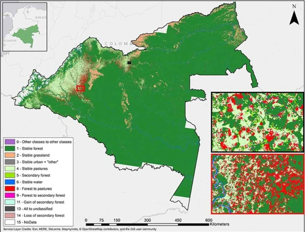
The Geospatial AI Solution: AI algorithms continuously monitor satellite feeds to provide near real-time deforestation alerts. They can distinguish between natural forest changes and human-caused clearing.
- Real-World Impact: Global Forest Watch uses AI to empower local authorities and conservation groups with timely alerts. This enables faster on-the-ground intervention to stop illegal activities before they escalate.

3. Creating a Sustainable Future for Agriculture
The Challenge: The world needs to produce more food with fewer resources while adapting to a changing climate.
The Geospatial AI Solution: “Precision agriculture” uses AI to analyse drone and satellite imagery of farmland. The models can identify crop stress, detect early signs of disease, predict yields, and optimize the use of water and fertilizer.
- Real-World Impact: At Aya Data, our models have helped maize farmers in Ghana increase yields by up to 30%. By detecting disease weeks earlier than the human eye, we provide actionable data that boosts food security and farmer income.
4. Bolstering Disaster Response and Resilience
The Challenge: During a natural disaster like a flood or wildfire, emergency responders need immediate information on the extent of the damage to save lives.
The Geospatial AI Solution: After an event, These AI models can rapidly compare pre- and post-disaster satellite images to create accurate damage assessment maps.
- Real-World Impact: The Copernicus Emergency Management Service uses AI to provide these maps to global disaster relief teams, helping them prioritize rescue efforts, identify safe evacuation routes, and deliver aid more effectively.
The Future: From AI Insights to Autonomous Action
The next evolution is Agentic AI. Imagine an autonomous AI agent tasked with a goal like “Reduce plastic pollution in the South Pacific.” or in “Africa”
This agent could independently:
- Analyze ocean current data and satellite imagery to predict where plastic waste will accumulate.
- Task a fleet of drones to fly over these “hotspots” for high resolution verification.
- Automatically communicate the coordinates and tonnage to cleanup organizations.
This is the future we are building a world where intelligent systems become active partners in environmental stewardship.
The end goal is producing advanced, self-developing models that accurately predict manmade and natural deforestation events, allowing governments and NGOs to take swift evasive action prior to damage taking place.
Conclusion: Let’s Build a More Sustainable Future
Geospatial AI provides the clarity and scale needed to address our most pressing environmental issues. It is a critical tool for building a more sustainable and resilient world.2
If you are ready to harness the power of Geospatial AI for your organization, contact us today. Let’s discuss how we can turn data into action.
Frequently Asked Questions (FAQ)
Isn’t this just GIS?
While related, they are different. A GIS (Geographic Information System) is a tool for managing and visualizing map data. Geospatial AI uses that data to perform predictive analysis, identify patterns, and automate insights at a scale no human could.
How accurate is Geospatial AI?
For well defined tasks like deforestation detection or crop classification, modern Geospatial AI models can achieve accuracy levels exceeding 95%. This precision is vital for making confident, data-driven decisions.
Who can benefit from Geospatial AI?
Any organization whose success is tied to the physical world. This includes agriculture, renewable energy, insurance (for risk assessment), urban planning, and supply chain logistics. It provides a powerful edge in efficiency, sustainability, and risk management.


